

"The Rip" Poster
Designed and sold by Clive
$24.18
Style

PosterHeavy poster paper, semigloss finish
$24.18
Product features
- Printed on poster paper. Extremely versatile, making it perfect for reproducing both artwork and photographs
- Custom sizes, based on artwork dimensions. Check size chart if self-framing
- Dimensions include a 1 - 2 inch (2.5 - 5.0cm) white border to assist in framing
- Shipped in protective packaging
- Since every item is made just for you by your local third-party fulfiller, there may be slight variances in the product received

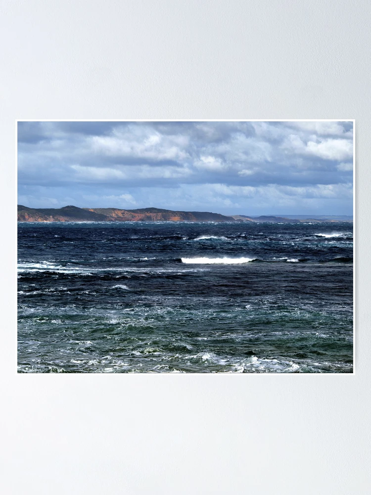
"The Rip"
Image taken during stormy weather at Port Phillip Heads, a stretch of water known as "The Rip". Camera Olympus E-520, Focal length 70.0mm, Shutter 1/500s, f7.1, ISO100. Slight work with Dynamic-Photo HDR. . "The Rip" is a dangerous streach of water in Victoria, Australia, connecting Port Phillip and Bass Strait. It is the only entrance for shipping into Port Phillip and hence into Melbourne. Because of large tidal flows through the relatively narrow channel from the bay to the ocean, and a high rocky seabed, The Rip has claimed many ships and lives. Geographically, it is the roughly triangular area of water between the land points of Point Nepean, Shortlands Bluff and Point Lonsdale, these 3 known as the heads. Within 800m outside the Heads, there is a shallow rocky flat known as the Rip Bank. The water deepens outside this flat to 30m and inside the Heads to as much as 90 m. This inequality of depth combined with tidal streams running up to 6 knots, causes the world-renowned dangerous conditions. The variation in seafloor depth within the rip itself can be anywhere from 50m to less than 5m amongst the rocky reefs and shoals. Entering the heads of Port Phillip is a risky and dangerous procedure, with many sailors regarding it as one of the most dangerous shipping paths in the world. Control of shipping movements through the heads is managed by the Point Lonsdale Signal Station. Large ships may only enter Port Phillip with a qualified pilot aboard to help them navigate through the heads. The heads are very narrow, having a width of approximately two kilometres. When entering, large ships have to follow a precise S-shaped course through the heads. Before the availability of Global Positioning System, many sailors used the two historical lighthouses on Queenscliff as a guide to get into the bay without hitting bedrock. A feature of the pair of lighthouses is that one is black and the other is white. The idea behind this is so that sailors, when using the lighthouses as a guide to get into the heads, can tell the two lighthouses apart and avoid confusion that could lead to disaster.
Also available on


Looking for something different?
Search below.Related Tags
Posters Tags
This section provides a collection of tags that relate to the Poster on this page. These tags each link to a search for the Posters that relate to the tag.
All Product Tags
This section provides a collection of tags that each link to a search for any products that relate to the tag.
Trending topics
This section provides a collection of tags that each link to a search for any products that relate to the tag.
Secure Payments
100% Secure Payment with 256-bit SSL encryption


